Archive
Westward Gold Provides Update on 2024 Exploration Activities at Toiyabe Hills
 | |||||||||
 |  |  |  |  | |||||
Vancouver, British Columbia, August 1, 2024 – TheNewswire – Westward Gold Inc. (CSE: WG, OTCQB: WGLIF, FSE: IM50) (“Westward” or the “Company”) is pleased to provide an update on 2024 exploration activities at its flagship Toiyabe Hills consolidated land package, situated along the Cortez Trend in Lander County, Nevada. The primary goal of the programs – designed by Westward’s technical team with a history of significant Carlin-type gold discoveries to their credit – is to define new high-priority drill targets on the Company’s 55-square kilometer property.
The highlights of ongoing and upcoming field programs are as follows:
-
1:5000 district-scale, Anaconda-style geological mapping continues, led by Vice President Exploration Robert Edie and Technical Advisor Steven Koehler
-
A rock-chip sampling program is ongoing, focused on areas of interest identified during mapping; to date, 143 samples have been submitted for assays, and collection will continue throughout the season
-
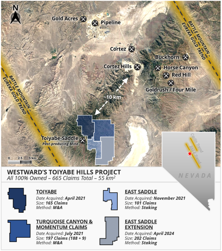
Collection of soil samples began in July, across a grid designed to fill in data on previously-unsampled ground, notably, the newly-acquired East Saddle Extension Claims (see Figure 1 below)
-
Engaged MWH Geo-Surveys International Inc. to conduct a gravity survey across the entire property, improving upon inherited data with tighter station spacings; program will commence in early August
Following completion of the programs outlined above, Westward’s technical team will consolidate and analyze all available data to rank drill targets using both a proprietary scoring system, and their vast personal experience working on Carlin-type gold systems. Investors can expect these top target areas to be discussed in detail in the coming months.
Figure 1: Westward’s Toiyabe Hills Project
Westward Strategic Advisor Kelly Cluer recently returned from a site visit to Toiyabe Hills, and noted the following: “Having completed structural transects across this large, consolidated land package, the district-scale opportunities now available to the Company become readily apparent. From the known gold mineralization at Toiyabe on our west flank – adjacent to a past-producing open-pit mine – across to the central and eastern sectors, there is a repetition of both structure and stratigraphy. Indications are that the previously-identified “Hilltop Corridor” is a feature with scale that is significantly underexplored, with mapped large displacement structures near the axis of an antiform, gold and arsenic geochemical anomalies, multi-phase igneous dikes including lamprophyre, and lower-plate strata at manageable drilling depths. I’m very confident that the systematic field work currently being undertaken will yield several high-quality targets in the near future. This is emblematic of the opportunity that can be created in Nevada, practically in the shadow of large long-lived gold camps, with strategic land acquisition and discovery-oriented exploration tactics.”
To date, 1:5000 Anaconda-style geological mapping has covered approximately 9 square kilometers, building upon previous mapping campaigns that were focused on the original Toiyabe claims block. With the benefit of Westward’s successful land consolidation since that time, the current program has moved eastward and southward, with the intention of covering the entire land position. So far, the Company has identified three new, large alteration zones in upper- and lower-plate rocks which exhibit geological characteristics consistent with many Carlin-type gold deposits in the area. These include dike-filled fault corridors (dike swarms), multiple igneous rock types, repeating sections of favourable stratigraphy, multiple compressional tectonic events, and exposures of punky-decalcified and oxidized limestone. The vast majority of Toiyabe Hills (including the Turquoise Canyon, East Saddle and East Saddle Extension claim blocks), remains untested with drilling.
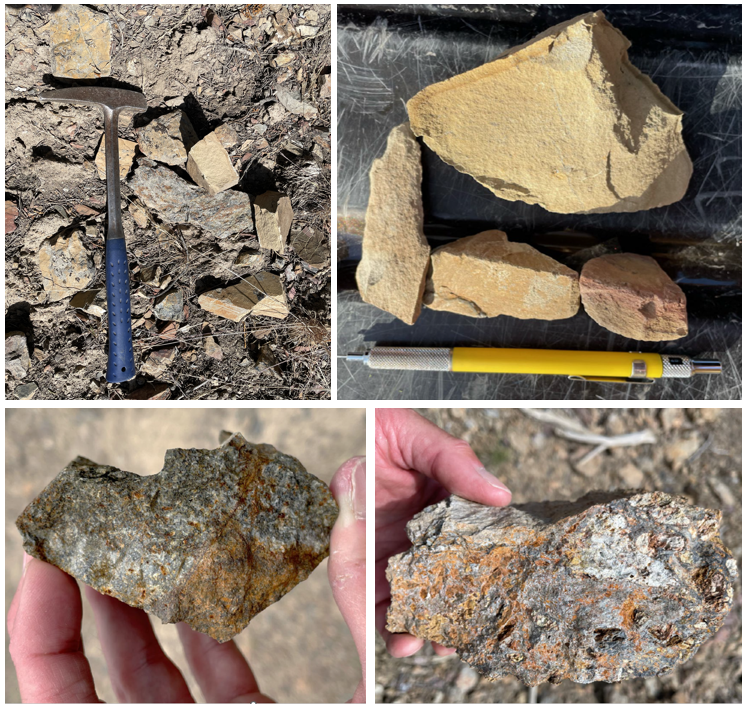
Westward geologists have collected 143 surface rock-chip samples for analysis, largely focused around the aforementioned alteration zones. These samples are characterized by alteration assemblages consistent with known Carlin-type gold deposits in the region, and include oxidized-decalcified-locally silicified silty limestone of the Wenban Formation, oxidized-sulfidized-clay altered igneous dikes, and quartz-barite veined siliciclastics of the Vinini Formation; select examples are shown in Figure 2 below. Samples have been submitted for gold and multi-element analysis to further enhance the Company’s drill target definition, and additional sample collection will continue throughout the remainder of the field season.
Figure 2: Toiyabe Hills Rock-Chip Sampling

Figure 2 (Top): “Punky” decalcified and oxidized Wenban Formation silty limestone
Figure 2 (Bottom left): Oxidized, sulfidized, +/- clay altered igneous dikes
Figure 2 (Bottom right): Oxidized / clay altered breccia along the Roberts Mountains’ Thrust
A gravity survey with 200-meter station spacing will be conducted in August. Tightly-spaced gravity surveys deliver powerful data in the exploration of Carlin-type gold systems, particularly as a tool for mapping the subsurface location of mineralization-controlling faults, fractures and alteration zones. This will provide another cost-effective targeting tool, narrowing search areas to those most prospective for gold deposition.
Corporate Update
Westward is pleased to confirm its attendance at the upcoming 2024 Precious Metals Summit in Beaver Creek, CO, from September 10th to 13th. Representatives from the Company – including the CEO, CFO and Vice President Exploration – will be meeting with institutional investors, corporates, and other interested parties. Please reach out to the Company if you are attending and would like to connect.
Sampling Methodology, Chain of Custody & Quality Assurance / Quality Control
The Company implements a best-practices QA/QC program during surface sampling programs. All rock-chip samples have been collected by Westward Gold geologists. Coordinates for each sample are collected by Garmin GPS units in datum UTM NAD 83 Zone 11 meters and recorded in a spreadsheet, along with a visual description of each sample. Samples were transported by Robert Edie to Bureau Veritas’ (“BV”) certified preparation facility in Sparks, NV, where they are crushed and pulverized. Resulting sample pulps (30g sample size for gold and 500mg for multi-element) will be analyzed in either Sparks, NV for fire assay or Vancouver, BC for multi-element assays. BV is independent of the Company. Certified reference materials (“CRMs”) purchased from Moment Exploration Geochemistry in Lamoille, NV, were inserted into the rock chip sample stream at a frequency of one every 25th sample (4%).
Qualified Person
The technical information contained in this news release was reviewed and approved by Robert Edie, Vice President Exploration of the Company, who is a Qualified Person under National Instrument 43-101 – Standards of Disclosure for Mineral Projects. Mr. Edie is a Certified Professional Geologist (CPG) through the American Institute of Professional Geologists (AIPG).
About Westward Gold
Westward Gold is a mineral exploration company focused on developing the Toiyabe Hills Project located in the Cortez Hills area of Lander County, Nevada, and the Coyote and Rossi Projects located along the Carlin Trend in Elko County, Nevada. From time to time, the Company may also evaluate the acquisition of other mineral exploration assets and opportunities.
For further information contact:
Andrew Nelson
Chief Financial Officer
Westward Gold Inc.
+1 (604) 828-7027
andrew@westwardgold.com
www.westwardgold.com
The Canadian Securities Exchange has neither approved nor disapproved the contents of this news release. The Canadian Securities Exchange does not accept responsibility for the adequacy or accuracy of this news release.
This news release contains or incorporates by reference “forward-looking statements” and “forward-looking information” as defined under applicable Canadian securities legislation. All statements, other than statements of historical fact, which address events, results, outcomes, or developments that the Company expects to occur are, or may be deemed, to be, forward-looking statements. Forward-looking statements are generally, but not always, identified by the use of forward-looking terminology such as "expect", "believe", "anticipate", "intend", "estimate”, “potential”, “on track”, “forecast", "budget", “target”, “outlook”, “continue”, “plan” or variations of such words and phrases and similar expressions or statements that certain actions, events or results “may”, “could”, “would”, “might” or “will” be taken, occur or be achieved or the negative connotation of such terms.
Such statements include, but may not be limited to, information as to strategy, plans or future financial or operating performance, such as the Company’s expansion plans, project timelines, expected drilling targets, and other statements that express management’s expectations or estimates of future plans and performance.
Forward-looking statements or information are subject to a variety of known and unknown risks, uncertainties and other factors that could cause actual events or results to differ from those reflected in the forward-looking statements or information, including, without limitation, the need for additional capital by the Company through financings, and the risk that such funds may not be raised; the speculative nature of exploration and the stages of the Company’s properties; the effect of changes in commodity prices; regulatory risks that development of the Company’s material properties will not be acceptable for social, environmental or other reasons, availability of equipment (including drills) and personnel to carry out work programs, that each stage of work will be completed within expected time frames, that current geological models and interpretations prove correct, the results of ongoing work programs may lead to a change of exploration priorities, and the efforts and abilities of the senior management team. This list is not exhaustive of the factors that may affect any of the Company’s forward-looking statements or information. These and other factors may cause the Company to change its exploration and work programs, not proceed with work programs, or change the timing or order of planned work programs. Additional risk factors and details with respect to risk factors that may affect the Company’s ability to achieve the expectations set forth in the forward-looking statements contained in this news release are set out in the Company’s latest management discussion and analysis under “Risks and Uncertainties”, which is available under the Company’s SEDAR+ profile at www.sedarplus.ca. Although the Company has attempted to identify important factors that could cause actual results to differ materially, there may be other factors that cause results not to be as anticipated, estimated, described or intended. Accordingly, readers should not place undue reliance on forward-looking statements or information. The Company’s forward-looking statements and information are based on the assumptions, beliefs, expectations, and opinions of management as of the date of this press release, and other than as required by applicable securities laws, the Company does not assume any obligation to update forward-looking statements and information if circumstances or management’s assumptions, beliefs, expectations or opinions should change, or changes in any other events affecting such statements or information.
